 Knuckles Mountain Range
 The Knuckles is situated in the Districts of Kandy and Matale extends from Laggala to Urugala a distance about 19 Km, covers an area of 160 Km2 . The term Knuckles is used in three senses, namely, as the Knuckles massif, the Knuckles Range, and the Knuckles Peaks. The Knuckles massif about 90 square miles in extent, is a detached block of the Central Highlands, separated from the main highlands by the Dumbara Valley. A group of five peaks that took like the Knuckles of a clenched fist. The highest point on the range is Gombaniya (1906m). The next highest point in the Knuckles range is the Knuckles (1864m). There are several other peaks in the range that rise over 5000 ft. including Kirigalpotta (1648m), Dotugala (1575m) and Kobonilgala (1555m).
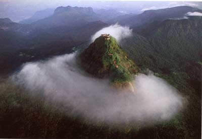
Adam’s Peak.
Jutting sharply skyward from the lush jungles of southwestern Sri Lanka is the 7362 foot (2243 meter) peak of Sri Pada, the 'Holy Footprint'. Also called Adam's Peak, the mountain has the unique distinction of being sacred to the followers of four of the world's major religions: Hinduism, Buddhism, Christianity and Islam. Long before the development of these religions, however, the mountain was worshipped by the aboriginal inhabitants of Sri Lanka, the Veddas. Their name for the peak was Samanala Kanda; Saman being one of the four guardian deities of the island. For Hindus, the name of the mountain is Sivan Adi Padham, because it was the world-creative dance of the god Shiva that left the giant footprint (5 feet 7 inches by 2 feet 6 inches). According to Buddhist traditions from as early as 300 BC, the real print is actually beneath this larger marking. Imprinted on a huge sapphire, it was left by the Buddha during the third and final of his legendary visits to Sri Lanka.

Hakgla Mountain
Mountain is situated in Nuwara Eliya district of Sri Lanka at 2,169 m (7,116 ft) above mean sea level . Most parts of the mountain is coverd with forest witch belongs to Hakgala Strict Nature Reserve. Hakgala Botanical Garden is situated in the NorthEastern steep of the Hakgala mountain. SouthWestern side of the mountain has a wet climete compared to NorthEastern steep since SouthWestern part faces derectly to South-West Monsoon.
 Hanthanan Mountain
 The Hanthana Mountain range is a beautiful delightful set of hill tops which are stunning with lush panoramic views. Overlooking grassy plains and eucalyptus trees lining the estates, you will see friendly faces of the estate workers greeting you. Driving breezily along the well-paved road, you will meander on the first and second Circular Roads which lead up to the Hanthana Housing Scheme. Also, the Forest Reserve road where the Circuit Bungalow is located offers sightings of hedgehogs, mongoose, rabbit and occasional wild boar spottings. The best aspect about Hanthana and the housing scheme is that the residents live in harmony with the animals and the peaceful and serene environment is testament of that.The range is also a big hit with hikers and adventure seekers where they do a good hike by traveling up to the point which has seen rapid development in the form of communication towers. The Hanthana mountain range comprises of more than seven peaks dotted gracefully. Hanthana is spread on the outskirts of Kandy from which many glorious rivulets and streams flow. One such stream flows past the village of Udaperadeniya and the University. The Hanthana mountain range spans from Galaha to Kandy with a spanning direction which is from north-west to south-ea.

Kirigalpottha Mountain
Kirigalpottha mountain is second highest mountain of Sri Lanka. Highest mountain of Sri Lanka is Piduruthalagala mountain. It's situated near Nuwaraeliya. It's 2524m high above sea level. Second of Sri Lanka means Kirigalpottha is 2395m above sea level. This mountain situated at Nuwaraeliya district of Sri Lanka and the Horton Plains. Third of Sri Lanka means Totupala mountain is situated east side of the Horton plains and This is situated west side of the Horton plains.Kirigalpottha has lot of things to see. Specially endemic birds, endemic plants, endemic animals and more about the nature. Especially you can see Binara flowers, Marathmal flowers ( scientific meaning=Rhododendron arboreum ), deer, horn chameleon, jungle fowl which also endemic to Sri Lanka and leopards. Leopards are kept for this place for being equilibrium. Travel to this place is some what different. First you come to Horton plains and come to the car park and museum of Horton plains. Then you have to go another forest way along 12km. There is no way to travel but tourist travel with those difficulties.

Namunukula Mountain
Namunukula mountain is very important mountain of Sri Lanka and which is situated border of Badulla and Monaragala Districts and main mountaon of Badulla situation. Hantana Mountain is Lovers mountain of students of University of Peradeniya as we know. How ever one day Namunukula became lovers mountain of students of University Of Uva Wellassa Sri Lanka. There are main two entrance to enter Namunukula mountain. Namunukula is at Passara. Passara is provincial Division of Badulla district.

If you like to travel Namunukula first you should come to Passara place. Then you can climb to top of the Namunukula Mountain.In this moment I thought some lyrics parts of some singers. They are "Thumuna Namunukula" and "Meedum Saluthira Palandi Namunukula".This song describe that how about comfortable at Namunukula. See and feel.
Piduruthalagala Mountain
Piduruthlagala is the Highest mountain and highest top of the Sri Lanka. Top of the Piduruthalalgala mountain is high 2524m above sea level. this mountain is very beautiful and very cool mountain of Sri Lanka. piduruthalagala cool climate is very wonderful.Most highest pot of Sri Lanka called Piduruthalagala and top of this mountain and meter to every place of Sri Lanka with their distance and vector. Piduruthalagala mountain is at Nuwaraeliya place and secret plants secret animals and various things are hidden in there. Most plants and animals are endemic to Sri Lanka. Soma plants which are only grows at Himalayas of India are grows in this mountain.Their is a coolest and highest village of Sri Lanka called Shanthipura which is at between Nuwaraeliya city and Piduruthalagala mountain. Their are busses to Shanthipura and Nuwaraeliya but shutters of this buses are can not opened. Because thir is very cool. Most big Radar station and most powerful Sri Lankan Sri Lanka Rupavahini television tower is situated at top of Piduruthalagala mountain.In security seosons sometimes you may not permit to enter or climb this mountain.

Sri Pada Mountain
The only mountains in the world where four major religions get together and worship. To the Buddhist, the imprint found on the summit of the mountain is the hallowed footprint of the Lord Buddha hence the Name “SriPada”. To the Hindus, the footprint is that of God Shiva. To the Christians, it is the footprint of St. Thomas, and to the Islam, it’s the foot print of Adam, hence the title “Adam’s peak”. Another name given by Sinhalese is “Samanala Kanda” meaning Butterfly Mountain due to the fleet of butterflies fling around with the start of the season.It is 2243m in height above the sea level and about 27km (16 miles) from bottom to the top by foot or 14.4km(9 miles) by vehicle and 12km (7 miles) by foot to the top of the pointed peak.

Thotupola Mountain
Thotupola Kanda (mountain) in Horton Plains is the third highest point in Sri Lanka (2360 metres above sea level). The climb to the top is quite easy and a good starting point for a young hiker. When you travel from Nuwara Eliya to Horton Plains via Pattipola - Ohiya Road, The trail entry point lies about 400m from Pattipola main entrance of the Horton Plains Reserve. The entire hike to the top will take about 1 hour and the total climb will be less than 200m. The first bit will be through tall shrubs and then you will come to an open terrain with shorter shrubs. You need to come to a mini peak before the Thotapola main peak. The top of the mountain is full of thick vegetation so it is bit diffcult to see a panaromic view but still the view is awesome. You can clearly see a good half of the plain and Farr Inn (The place where world's end trail starts) from the peak.Since this peak is within the nature reserve you need to get prior approval from the Department of Wild Life.

Udamala mountain
Udamala mountain is one of the very beautiful mountain in Sri Lanka which is situated at the border of Badulla and Nuwaraeliya districts and more than 1850m above see level. In the morning the mountain looks clearly in Alawathugoda village and afternoon mist come and cover the mountain and hide it.
You can travel to top of the mountain with one and half hour walking from Alawathugoda. It's very difficult and interesting one. You can travel to Worlds End trough the forest. There has a lot of endemic plants, animals and trees. Some of them is Binara, Ma rath mal, Meewana, Wali kukula, Horn leopard like this.Before the 1818 era udamala is named Narabootagala because people was hid on Udamala. You can find more about it with move to History page.Udamala mountain has various type of natural items. On the way of Udamala is Started near Diyawatanalla waterfall. Pass the Diyawatanalla you met a special rock called "Pandas Gala" means the rock is situated on the border of 5000 feet above sea level. Pass this traveler think now I'm climb 5000 feet from sea level. Next traveler meet big garden which grows Eucalyptus trees. Next you should travel 5 km you come the very beautiful place called "Handa bage" means half of moon mountain.
No comments:
Post a Comment